- ENGINE AND BOAT SALES
-
NAUTICAL PRODUCTS
- Inflatable boats
-
Boat Hardware
Boat Hardware
- Stainless steel cables accessories
- Clinometers
- Running Rigging Ropes
- Knives and accessories
- Sail Furlers
- Maintenance and repair
- Tiller brakes and extensions
- Wind indicators
- Fairleads and Eye Straps
- Shackles and Snap Hooks
- Blocks and organizers
- Tracks and travellers
- Turbuckles, Clevis and Cotter pins
- Spinaker poles and Bowsprits
- Cleats, Cam Cleats and Clutches
- Winches and accessories
- Mooring and docking
- Comfort
-
Electrical
Electrical
- Alternators and regulators
- Navigation light bulbs
- Marine Batteries, selectors and monitors
- Shore power cords and power inlets
- Wire and battery terminals
- Electrical Distribution
- Marine Navigation lights
- Tinned Wires 12V and 120V
- Inverters and chargers
- Exterior lighting and spotlights
- Interior lighting
- Solar Panels and Fuel Cells
-
Electronics
Electronics
- GPS, Multifonction Network displays and Chartplotters
- VHF and TV antennas
- NMEA 2000 Network and Cables
- Electronic charts and softwares
- Navigation instruments, Depth, Speed and Wind
- Fishing Trolling Motor
- Cockpit Autopilots
- Below deck autopilots
- Radars
- Fixed mount VHF radio
- Handheld VHF radio
- Transducers depth and fishing
- Sound systems and speakers
- AIS transponders and receivers
-
Maintenance
Maintenance
- Finishing and antifoulling paints
- Non Skid Paint and Anti-Slip Deck Covering
- Epoxy Resins and fiber accessories
- Marine cleaners
- Waterproofing and Treatment Products
- Finishing compounds and waxes
- Varnish, Teak Oil and Teak Cleaner
- Gelcoat restoration
- Sealants and adhesives
- Painting and Maintenance Supplies
- Synthetic deck
- Engine
- Navigation
- Plumbing
- Hardware
- Safety
- Sports and Entertainment
- Marine Clothing
- WATERSPORT STORE
- MARINE CLOTHING
- BLYACHT STORE
- SALES - NEW PRODUCTS
- LIQUIDATIONS
- Boulet Lemelin Yacht>
- Catalog>
- Safety>
- Beacons>
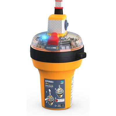
- Ocean Signal rescueME EPIRB3 CAT2 (manual)
Ocean Signal rescueME EPIRB3 CAT2 (manual)
Product Code: 0903932
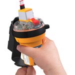
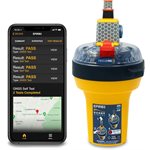
The new Ocean Signal rescueME EPIRB3 is a full featured 406 MHz global GMDSS Approved Emergency Position Indicating Radio Beacon that comes with a manual release bracket and packs a host of features into a compact modern design which includes AIS technology. AIS provides local rescuers precise and reliable information on the current beacon position, thereby speeding rescue operations. Additionally, Return Link Service (RLS) comforts those who activate the beacon by confirming that their distress message has been received. The inclusion of Near Field Communication (NFC) capability allows use of a smartphone app to monitor the EPIRB’s battery and other functions ensuring it is working properly. With its slim design and advanced features, the EPIRB3 is ideal for a variety of mariners whether they are cruising the med, heading out through the straights for a passage, fishing, working, or sailing offshore.
The EPIRB3 uses the GNSS (GPS, Galileo, Glonass) positioning networks to derive its location globally. When the beacon is triggered a 406 MHz distress transmission relays this GPS EPIRB (GPIRB) position, accurate to within 100 meters, to the worldwide Comsat-Sarsat search and rescue satellite network. Ground stations connected to the satellite system receive EPIRB identification and position of deployment information so rescue operations can be coordinated and initiated. With advanced AIS technology now incorporated into the EPIRB, directly upon activation the beacon starts transmitting AIS signals so that nearby AIS equipped vessels are instantly notified of the distress situation and are provided the beacon location. AIS equipped vessels within VHF range will see a safety message on their screens that includes the MMSI vessel identification. Local vessels can start rescue and recovery operations immediately, potentially speeding recovery times and saving lives. Since an AIS target is presented on the onboard display of any nearby AIS equipped vessel, they can easily navigate directly to the EPIRB by selecting the AIS target. Even when no local vessels are available, AIS will speed recovery times by allowing maritime SAR operators to pinpoint the EPIRB’s location as they approach. The combination of Global satellite distress calling, precise GPIRB location transmission and local AIS safety messaging will greatly improve recovery time and success.

