- ENGINE AND BOAT SALES
-
NAUTICAL PRODUCTS
- Inflatable boats
-
Boat Hardware
Boat Hardware
- Stainless steel cables accessories
- Clinometers
- Running Rigging Ropes
- Knives and accessories
- Sail Furlers
- Maintenance and repair
- Tiller brakes and extensions
- Wind indicators
- Fairleads and Eye Straps
- Shackles and Snap Hooks
- Blocks and organizers
- Tracks and travellers
- Turbuckles, Clevis and Cotter pins
- Spinaker poles and Bowsprits
- Cleats, Cam Cleats and Clutches
- Winches and accessories
- Mooring and docking
- Comfort
-
Electrical
Electrical
- Alternators and regulators
- Navigation light bulbs
- Marine Batteries, selectors and monitors
- Shore power cords and power inlets
- Wire and battery terminals
- Electrical Distribution
- Marine Navigation lights
- Tinned Wires 12V and 120V
- Inverters and chargers
- Exterior lighting and spotlights
- Interior lighting
- Solar Panels and Fuel Cells
-
Electronics
Electronics
- GPS, Multifonction Network displays and Chartplotters
- VHF and TV antennas
- NMEA 2000 Network and Cables
- Electronic charts and softwares
- Navigation instruments, Depth, Speed and Wind
- Fishing Trolling Motor
- Cockpit Autopilots
- Below deck autopilots
- Radars
- Fixed mount VHF radio
- Handheld VHF radio
- Transducers depth and fishing
- Sound systems and speakers
- AIS transponders and receivers
-
Maintenance
Maintenance
- Finishing and antifoulling paints
- Non Skid Paint and Anti-Slip Deck Covering
- Epoxy Resins and fiber accessories
- Marine cleaners
- Waterproofing and Treatment Products
- Finishing compounds and waxes
- Varnish, Teak Oil and Teak Cleaner
- Gelcoat restoration
- Sealants and adhesives
- Painting and Maintenance Supplies
- Synthetic deck
- Engine
- Navigation
- Plumbing
- Hardware
- Safety
- Sports and Entertainment
- Marine Clothing
- WATERSPORT STORE
- MARINE CLOTHING
- BLYACHT STORE
- SALES - NEW PRODUCTS
- LIQUIDATIONS
- Boulet Lemelin Yacht>
- Brands>
- GARMIN>
- Electronics>
- Electronic charts and softwares>
- Garmin BlueChart g3 HD New Generation ( USA / Canada / Bahamas )
Garmin BlueChart g3 HD New Generation ( USA / Canada / Bahamas )
Product Code: 0201468.US39
Chart SD/Micro SD format
Provides detailed coverage of the eastern coast of the U.S. from Key West, FL to the Canadian border and the western coast from the Mexican border to Puget Sound, Alaska, Hawaii and major inland rivers, the U.S. Gulf Coast to the Mexican border and the Mexican Gulf Coast thru to the Yucatan. Canadian coverage includes the entire St. Lawrence Seaway, Nova Scotia and New Brunswick. The Great Lakes are covered in their entirety as are the Lake of the Woods. Coverage includes Prince Edward Island, Anticosti Island, Vancouver Island including the Inside and Outside Passages, Aleutian and Channel Islands, Bahamas, Turks and Caicos Islands, Cozumel, Cuba, Hispaniola, Puerto Rico and the U.S. Virgin Islands.
Version Enhancements:
See your vessel’s precise, on-chart position in relation to navaids, coastal features, anchorages, obstructions, waterways, restricted areas and more with this detailed marine mapping data.
• Shaded depth contours, coastlines, spot soundings, navaids, port plans, wrecks, obstructions, intertidal zones, restricted areas and IALA symbols.
• Seamless transitions between zoom levels and more continuity across chart boundaries.
• Standard 2-D direct overhead or 3-D “over the bow” map perspective for easy chart reading and orientation.
• Safety Shading* enables contour shading for all depth contours shallower than your defined safe depths.
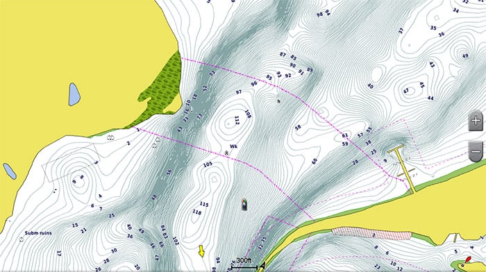
• Fishing Charts* to scope out bottom contours and depth soundings with less visual clutter on the display.
• Features up to 1-foot HD fishing contours which reveal detailed seafloor terrain.
• Plan and organize routes from your computer with HomePort™ (sold separately).
See your vessel’s precise position on-chart in relation to navaids, spot soundings, coastal features, anchorages, port plans, waterways, obstructions, restricted areas and more. BlueChart® g2 HD provides seamless chart presentation with 1-foot HD contours to provide a more accurate depiction of bottom structure for improved fishing charts and navigation in swamps, canals, marinas and port plans.
In addition to the basic charts, tidal stations, currents, depth contours, IALA symbols and included full bathymetric fishing charts with detailed contours, BlueChart g2 HD also offers smooth transitioning between zoom levels and seamless continuity across chart boundaries.
Customize Your Screens
BlueChart g2 HD also adds Shallow Water Shading to allow the user to enable contour shading for all depth contours shallower than the user-defined safe depth.
The fishing charts are designed to emphasize bathymetric contours with less visual clutter on the display.
There’s also a choice of standard 2-D direct overhead or 3-D “over-the-bow” map views for easier chart reading and orientation.
Detailed harbor information including lights, navigation lines, and tidal information show you the way home.

Fishing contours allow the user to have a clearer view of the ocean floor to catch more fish.
- Manufacturer's number : 010-C1018-20 HUS039
- Area : All USA


